An easy excursion, with minimal height differences, all on dirt road and only for short stretches on asphalt. There is a water supply at the fountain of Bigallo. Eat & Drink point: at Osteria Nuova.
Circular route
ACCESS: the Via del Bigallo car park
JOURNEY TIME: 3/4 hours
DIFFICULTY: ET
Bigallo (275m.) coordinates: 43° 44′ 20″ N 11° 20′ 59″ E
Osteria Nuova (227m.) coordinates: 43° 43′ 47″ N 11° 20′ 45″ E
The Route
The Bigallo – Valcelli – Ruballa
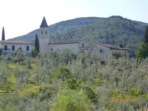
Having left the Via del Bigallo car park we take Via San Quirico a Ruballa and follow the directions of the “Borghi e colline” (Villages and hills) track. The road runs alongside the Hospital and continues alongside the walls of the Bigallo vegetable garden. On the left, in the countryside rich with olive groves, rises the Villa di Valcelli surrounded by a wreath of cypress trees. A few steps ahead, we find the farmhouse of the Valenzana farm, formerly attached to the Cortaccia farm. Beyond the house we can see the tops of pine, cypress and oak trees that form a small grove which the older locals would call the “Cipressaina”.
The road, which has now become a grassy path, begins to go descend and at the point where it turns left we can catch a small glimpse the building of the Quarto di sopra farm.
After crossing a long dirt road, the route climbs, skirting the perimeter of the Valcelli park and then progresses in a cool, shady tunnel of oaks which leads to the church of San Quirico a Ruballa. Continuing to the right on the dirt road bounded on the right by a tile-lined wall and on the left by a high wall punctuated by flourishing capers, we arrive at the church square.
Villa Le Corti a Ruballa – Villa la Torre – the valley of the borro di San Giorgio (ravine of Saint George)
From the church, having gone back and found the “Borghi e colline” (villages and hills) signs, we begin to descend. On the right we can see the farmhouse “Il Poderino”. The building, now restored, shows the remains of an ancient tower with a loft in its central part which was once attached to the Cortaccia farm.
We cross Via Roma (road no. 1) and notice the imposing structure of Villa Le Corti, locally called the “Cortaccia”, which preserves the appearance of a thirteenth-century fortified palace.
Continuing along the dirt road Via della Torre, we reach the municipal street Via Ubaldini Peruzzi which we follow keeping to the right. After passing the highway bridge, at the first crossroads we turn left to continue along the old route of Via Ubaldini Peruzzi. Along this stretch we can see the whole complex of Villa La Torre, a longtime residence of the Peruzzi, which in recent years has been completely renovated and converted into private residences.
Gradually we descend towards the Isone crossing Val di Lucciole (Valley of the Fireflies). Once we reach the river, which in this part is called the borro di San Giorgio (the ravine of Saint George), we ascend to the homonymous tiny and picturesque residential area with characteristic houses and a washhouse still in business; a witness to the activity of launderers carried out in the past by the families who lived there.
As we continue our climb, we leave the “Borghi e Colline” (villages and hills) signs and, keeping to the left, continue towards Osteria Nuova.
San Giorgio a Ruballa – Osteria Nuova – San Quirico a Ruballa
Once we have reached the cemetery of San Giorgio and crossed the bridge on the highway, the white façade and the pointed bell tower of the church of Giorgio a Ruballa immediately appear.
Continuing, we passes through what is locally known as “Canto alla lepre” (Song to the hare), and reach Via Roma (road no. 1). Turning to the left, we continue and cross the village of Osteria Nuova. Of note, on the right, is the building topped by a dovecote known as the “Landrone”, here, in some places, in the eighteenth century, was the waystation to change horses and refresh travelers. A little further ahead we find the square dedicated to the Rosselli brothers and finally the particular architecture (1930) of the Circolo Ricreativo (Recreational Club). In the case we wish to avoid the asphalt roads, we can take Via Ivo Lazzeri, whose final stretch descends a flight of steps into Via Roma, near the Recreational Club. Continuing to descend in the direction of Florence, where we find all the well aligned houses of la Sara, we go up on the right into Via San Quirico a Ruballa which we will continue along until the Bigallo.
San Quirico a Ruballa – I Poderini – The Bigallo
The farmhouse “Il Santo” (The Saint) (now restored) welcomes us with a beautiful marble tabernacle depicting the Madonna and Child. Ascending, we then notice an early twentieth century house and then, on the left, the square and the steps leading to the front of the church of San Quirico. Immediately after the church we find the farmhouse Poderino della Chiesa. Amongst ample olive groves and, still on the right, we notice another “Poderino”, with its characteristic farmhouse. The path becomes flatter and shows the gate leading to the villa “L’Apparita” or “Il Querceto”. A few hundred meters more and the vegetable garden walls topped by ivy will announce the Bigallo to us, which brings our circular excursion route to its end.
Elisabetta Brunelleschi.
The Map
[mapsmarker layer=”13″]


